A Trip up Timpanogos - 2007
 Our Griffith Family Reunion was in Provo this year, and for several reasons I really wanted to get in a hike to the top of Timpanogos. I spent almost 9 years of my life living in the Provo area, attending BYU for under grad and graduate school before moving to California. I spent 9 years in the slumber of a huge mountain, Timpanogos, that rises 5000 feet above the Utah Valley floor, and based on where I am at today I feel I squandered my opportunity to get out doors while I was there. Regardless, spilt milk and water under the bridge, there was now a new chance to hike it. Not only this but it would be a good training exercise for the Mt. Olympus climb this coming July, and Aaron my brother-in-law who is accompanying me to Olympus could also come along. Additionally my Uncle Doug wants me to accompany several of his family members to climb the Grand Teton in late August and it would be a good training ground for that as well. I naively, and admittedly selfishly invited the entire group from the family reunion to attend, initially my sister Robyn signed up, but later decided to for go. The plan for the hiking party to depart early from Provo, start from the Timponooke trail on the American Fork side, hike to the top and then hike back down to the Provo side where we would meet up at noon with the rest of the family who would gather for a picnic at the picnic area at the Aspen Grove trail head. The projected distance was around 15 miles and the elevation gain around 4500 feet, so we'd have to start early to make the lunch on the other side.
 Our committed party consisted of : myself, my brother Josh, my brother-in-law Aaron Chandler, and the entire family of my Uncle Doug : wife Julie, daughter Alyse (18), son Garrett (15) and daughter Lauren (12). Monday the entire group spent the day at Seven Peaks Water Park, where we had a great time, but lots of sun and my Uncle Doug stubbed/scrapped his toe. Concerned I reconfirmed his commitment and decided that we would up our departure time by a half an hour. We went to bed tired from the sun, but agreed to meet downstairs at 3:45 am the following morning. As we gathered in the parking lot, Doug, Alyse and Julie's hydration packs were all leaking, $15 on sale unfortunately doesn't involve a water tight o-ring. We dumped the water out and decided to stop at a gas station and grab 6 liters of water. Each person in the party would have have 2 liters of water, I did not bring a water filter and we assumed this would be sufficient, a mistake that would come back to bite us later in the mid-day sun. As we headed up I-15 towards American Fork, I had the directions to the Timpooneke trail pulled up on the web browser on my Blackberry and noted we needed to take exit 287. Unfortunately during the construction in preparation for the 2002 Olympics the exits were renamed and it was exit 284 we needed, so we ended up driving an extra 10 miles out of the way up over the point of the mountain to Bluffdale, turning around and back to 284. After making our way through the town of American Fork we wound our way up the canyon towards the trail head in the dark, arriving in the parking lot by 5 am. The sun had not yet risen but pre-dawn gave enough light to easily see the trail. After using the restroom we set off on the trail, stopping at the trial register to sign our party in, noting there were two other groups already signed in for July 3rd. Twenty minutes up the trail we caught the first group two girls who were slowly making their way up the trail, we passed them and never saw them again.
  The lower section of the Timpooneke Trail climbs for the first 45 minutes through quakies before starting what is known as the Grand Staircase which is a series of long (but not too steep) switch backs that climb up into the upper basin. Just as we started on the switch backs the sun lit up the peaks in a beautiful show of alpenglow, what a sight to be able to behold this on Timp itself, a future trip per haps. At this time of year, (really late spring in the high country based on the fact the snow had only recently melted out) the Grand Staircase, and the upper basin are covered in a beautiful bed wild flowers. Knee high blue bell's mostly, but all others thrown in, I saw some of the largest lushest Indian Paintbrush I had ever seen. We made good time, hitting 10,000 feet in the upper basin by 8:30 am. The summit was now in fullview, 1700 feet above us, on a seeming razors edge ridge line. We began our long switches (again not too steep at all) up the side of the mountain towards the saddle of Mt. Timpanogos. As we crossed a snowfield we met the other party ahead of us Grant Wilson who at 76 years old, had already summited and was on his way down! Garret was well ahead of us at the saddle waiting for a fellow hiker who had started before us but passed us on the way up.
  Lauren (12 years old) got a bit freaked out by some sections of the trail leading up to the saddle. There were a couple of small snowfields where things were slippery or where the trail had washed out a bit on the talus slope, nothing dangerous but when your young and the slope is steep it can seem scary. Lauren's mom Julie and Josh and Aaron helped her get through these tight spots but by the time she reached the saddle she rattled and was in no mood to continue. We talked to her about what would make her feel most comfortable and she agreed that someone ahead and behind her and holding her hands would help. We rested for a bit and then started out for the summit, with Julie and Josh leading Lauren. This section of
 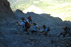 the trail is amazing set of engineering, the trail cuts along the edge of the ridge line with fairly steep talus drop offs below you. Despite the appearance from the photos of exposures, the slopes are not steep enough you would hurt yourself and the trail is wide enough to give you a real sense comfort that your not going to "fall off". The trail climbs up the ridge and then traverses a corner with some wickedly layered switch backs and then up and up towards the summit. As we approached the top, there was a mother and baby goat standing high on the ridge. I pushed hard to hit the summit before 10 am, and arrived huffing and puffing at the top, 11,750 feet at 10 am, where a hut sits, built many years ago for triangulation and surveying.
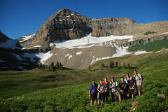
  At the summit we were all alone a bunch of Griffith's and one Chandler, we rested for a bit and posed for the summit shot. The normal course would be to then descend the same way we had come and make our way down the Aspen Grove trail passing by Emerald Lake. I had a bit more adventurous plan, to slide down the snowfield. So we headed along the top of the ridge line and descended a bit to reach the snowfield. Here we saw a couple of climbers stomping their way up the snowfield, they had full crampons, two ice axe a piece and were belaying, a bit of an overkill for warm snow that you could kick steps in all day long with flip flops, but hey I guess they need practice on the only "ice" in Utah. :) I explained glissading and how to slow yourself using a hiking pole (ice axes are what really works here, but since we didn't have any we made do). Doug took off first screaming his way down the glissade path, Aaron and Julie followed with no problems. Lauren was a bit freaked about sliding down. The initial slope of the snowfield is quite steep and can be a bit daunting, after 30 feet or so it starts to have a more gradual slope, but getting started takes a leap of faith. Lauren and I sat down together and she wanted me to slide with her. This was impractical, but once I got her going she had no choice but to commit and was fine. I went next and since I had given all my poles to others, I had only my feet and hands to slow my descent. I should have put my jacket on to help protect my wrists and arms, but forgot and things got a bit cold and tingly from the snow. I had to finally stop as my butt was numb and hurting from the snow.
 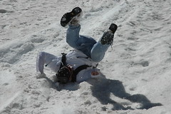 Next came Alyse and despite my coaching and the pole she had, she quickly got a bit out of control and did a somersault. She was a bit shaken up but was fine and made her way slowly down the snowfield. Josh had a fun time sliding down and also did a somersault at the end, but this was more out of fun than being out of control. We stopped for a break to warm our cold butts and hands and snapped another group photo in the snowfield and then headed down down the rest of the snow towards Emerald Lake.
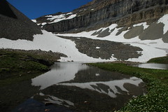 Emerald Lake is a small beautiful blue body of water that sits at the bottom of the snowfield and was at this time of year ice cold. Here we dug out the radios and split into two groups, the fast lead group (me, Garrett, Josh and Aaron) and the slow group (Doug, Julie, Alyse and Lauren), we should have also had we a water filter filled up on water, but we didn't. At this moment Aaron got a phone call from his brother regarding a networking issue with his business and stopped to spend 15 minutes on the phone resolving issues. Josh, Garret and myself pushed on through Hidden Lakes Cirque before beginning the descent through the wateralls of Primrose Cirque. This huge bowl is amazing to behold, a cascade of falling water and a series of cliffs with the high peaks of Timpanogos in the background. The trail crosses the many times water and passes by several waterfalls before taking an alarming left (as your looking down) out across a huge talus field. This is counter intuitive as the more direct route appears to follow the water straight down to the road (which is now in sight several miles down the trail). Unfortunately the water drops off many cliffs and the long switch backs get you down without falling. However it was now full on heat and the shadeless talus field began to cook my brain. By now we were running low on water and after 8 hours on the trail, and the pounding of the nerves in the bottom of my feet water is the last thing you want to be short on. Aaron caught up with Josh and myself (Garrett had sprinted on ahead) and Doug and Julie told us that Lauren was physically and emotionally exhausted and that Julie was carrying her. Josh gave me his pack (I know had two) and agreed to wait for Doug and Julie. Having the radios made contact so much easier (cell coverage is spotting as you dip in and out of this area) and we could also now talk to Stacey and the rest of the group waiting down at Aspen Grove.
 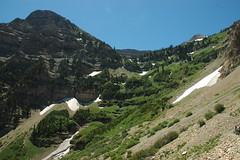 Aaron and myself pushed on, and hit the paved last mile of the trail that seemed to go on for ever. As we passed the trail head entrance to Aspen Grove, an appropriate sign read : "Hydrate or Die". We stumbled into camp where cold water and sandwiches were waiting. We then proceeded to talk to Doug and Julie periodically and encourage them on as they slowly made their descent into camp. As they were nearing the end I walked back up the trail a bit with some drinks. Doug and Julie looked exhausted, but later said they both enjoyed the hike. I am glad we went, the scenery was amazing and we all made it back safe and sound.
Stats : 9 hours
15 miles
4242 feet vertical
4271 feet descent
| www.flickr.com |
posted by Mark at
8:10 AM
![]()
![]()


1 Comments:
So this is the only way I could figure out to reply to your comment on my blog. Anyway, thanks, and go ahead and use the image I put together on your flickr stream.
Post a Comment
<< Home