High Alpine Traverse - Day One
How come no one told me about the blue shirt?: Brian Rudd

I spent a lot of time researching the route, pouring over Beckey's Bible and sending emails to back and forth with folks on NW Hikers, especially Dayhike Mike as well as Steve and Tisha. Dayhike Mike was a wealth of information, especially on the route from Tank around the southern slope of La Bohn and up the southern rib of Hinman. Steve came through with an amazing pano of Tank Lakes around to La Bohn gap that helped visualize Dayhike Mike's descriptions.
 I drove up to Cle Elum Tuesday evening to pick up Joe, his son Brian and my brother Josh. They had drove in from Boise and since our exit was Roslyn this would save them 2 hours driving back down to Issaquah and then out. Scott flew in that evening and caught a shuttle to our house. Joe and Brian were out and snoring by 10pm our time. I went to bed around 11 and was back up by 4:30 to put in some blue berry muffins for breakfast. The night before we had tied 3 packs on top of our Expedition and Josh and Scott stuffed theirs in the back. At 5 am Kevin Brown arrived who had graciously agreed to drop us at the trail head and we set out with hot muffins for Skykomish. We got to the Necklace Valley trail head around 7 and we were on the trail heading out by 7:35.
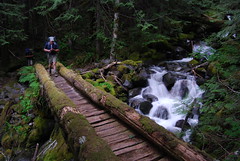
 The first 5 miles are the typical lower elevation Pacific Northwest hike, ferns, vine maple, devils club and lots of lush moss. The Foss River crossing was fine, despite the heavy snow melt the log bridge was in tact. Its kind of odd the way at 5 miles the trail just "ends" at a creek. You look around for a second thinking the talus field across the creek isn't the trail but the flagging on the trees and the natural log bridge convince you other wise. We headed up through the talus and the trail steepens as you begin climbing over the next mile quickly gaining elevation. The higher we ascended the foggier and mistier it got, so much so that while we weren't getting wet from the mist we were getting soaked from the wet slide vine maple and huckleberry bushes. We put on our pack covers and tried to stay dry. The sheer cliffs and the fog made for an otherworldly feeling.
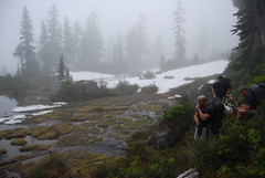
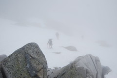
  When we arrived at small Jade Lake we hit the first patches of snow on the lake shore, Opal soon appeared and we stopped to consult the map, contours and headings as we set off to make our way to Tank Lakes. As we made our way through the trees in a south westerly direction the fog got thicker and the visibility shrunk, without ridge lines and landmarks navigation becomes a challenge. We kept consulting the lay of the land and contours and our heading, but with no perspective it was easy to keep doubting yourself. I had my GPS, but I generally only use it to track where I have been not navigate, in fact I have never even bought the extra topo package that Garmin charges $100 for and still have the regular city maps in it. Before we left I had meant to lay in a few waypoints, but my kids had misplaced my Washington Topo! CD's and so I didn't even have that to go on. So I dug way back into my scout orientation training and we took the latitude and longitude and were able to get rough coordinates of our general vicinity, but its still disconcerting to not be able to see any landmark ridge lines.
  Soon we were in snow and we came to the gully on the map that climbed up over the 6000 foot contour line and led towards Tank Lakes. I agreed to head up the steep gully and see where it led. As I got a short distance up, the pitch got to the point that a slip would result in sliding down and so I stopped and yelled down to the rest of the group :
"Time to break out those ice axes boys"
 We went over how to hold the ax and how to self arrest and then headed up the ridge into the unknown one slow step at a time. A 100 feet or so and the ridge leveled out and the terrain began to flatten and we began walking up through fields of heather and rock interspersed among the snow. We were tired and with visibility still at 40 feet it was clear even if we found the lakes we wouldn't be able to see them. So the first flat area we came to we agreed to stop and setup camp.
  Scott, Josh and myself camped on the granite while Joe and Brian pitched their tent on a small heather bluff overlooking something beautiful we supposed but with no visibility we weren't sure. We got our cooking gear out, boiled water and consumed our Mountain House. With no views, no sunset and no fire there wasn't much to do and besides it was cold, so we went to bed. I had opted to go light on this trip so I brought my summer bag, Sierra Designs Wicked Light, which was rated at 40 degrees. Its basically a big down blanket with a nylon bottom you can strap to a pad. I put my hat on my head and three layers on top, my pants on the bottom and two pairs of socks. I was ok warm most of the night, when Scott woke up around 1:15 or so to go to the bathroom and woke me up I snapped a quite photo of the stars as the sky had cleared and the milky way was so bright. Around 4:40 am I started to get pretty cold, my feet shivering a bit and my shoulder or hip getting cold where it was in contact with the pad... I held on for the first early morning rays when I could get out of my bag and walk around to warm up. I was excited to see the landscape around us where we'd settled in amongst the fog.
Day One Stats
6.79 Miles
4151 vertical feet
Photos
| Set on www.flickr.com |

0 Comments:
Post a Comment
<< Home