High Alpine Traverse - Day Two
A trail is not to be underestimated for its ability to
quickly and efficiently provide access to the wilderness.
But off trail, where the going is rough and much slower
is where the wild places still exist, adventure is found
and the beauty is unparalleled. : Mark Griffith
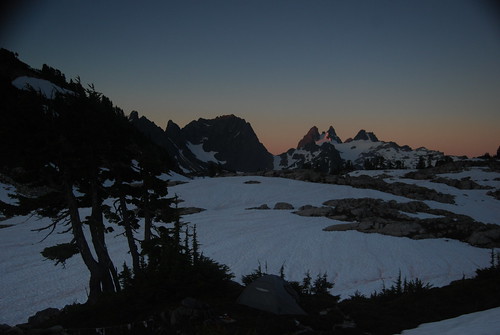
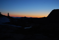 I got up and put on my puffy and my shell and my crocs. I avoided my wet boots, as there are few things that suck worse that putting your warm feet in dry socks into wet boots. There was ice on the small tarns and the snow fields were hard and crunchy. No wonder I was cold the temperature had fallen below freezing. I wandered north across the shelf among the tarns and snowfields. I slipped a couple of times as crocs aren't known for their grip on snow. I was looking to get a shot of the split skyline and Glacier Mountain against the sky. There was a lower blanket of fog that hung across the valleys a 1000 feet below. After snapping some photos from a higher peak I made my way back and started waking folks up.
 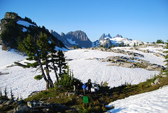 Everyone was all smiles as they woke and saw the amazing landscape the surrounded us; we were a scant 1/4 mile from Tank Lakes and had hit the navigation dead on and were right where we thought we had been. After breakfast we broke camp and got geared up. We'd be heading off trail today. Our first goal was to get up and over Mt. Hinman to the southern slopes of Mt. Daniel. This requires getting onto the southern slope of Hinman which is accessible from above La Bohn Lakes or via the La Bohn Gap. We had two possible routes, we could drop back down into Necklace Valley and ascend to the lakes via the steep waterfall ascent or we could maintain a higher elevation and head south of to Tank Lakes and descend to 5200 feet where a shelf would allow us to head east toward the La Bohn Gap above the Chain Lakes area. Following Dayhike Mike's suggested we opted for the high traverse on the 5200 shelf.
 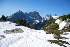 The descent down the ridge south from Tank Lakes is beautiful as you lip over the edge the Middle Fork opens wide and Summit Chief and the Overcoat Glacier and her peaks tower over head. You can see down into the bottom of the Middle Fork valley where Willams Lake sits at 4600 feet and look across at the Dutch Miller Gap. When you hit 5200 feet a shelf snakes along between a set of cliffs above and a set below. Like most natural features its not perfectly level and the shelf runs between 5200 and 5350 feet. The shelf is interspersed with ridges and water/avalanche chutes. At each ridge you have the choice to go up and over or down. The right thing to do is to stay above 5200 feet and most often that means going up.
 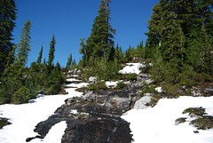 Unfortunately we learned the hard way, the first waterfall we came to we went down, which was a mistake. We dropped below 5200 feet and got cliffed out on the otherside and had to climb back up the next waterfall to regain the chute. Not dangerous but just steep tough and slippery with lots of vegetable belays. Once on top, the shelf lay out before us and we took a short break to catch our breaths. After tromping along the shelf and up and over a few ridges we came to a large talus field. Crossing this brought us the another ridge where we could finally see the ridge line of La Bohn Gap above the Chain Lakes. We ascended through more talus and snow and arrived just below the top of the ridge line. There was a big horn of rock ahead of us, we had to make way around the rock and onto the slopes of the La Bohn Gap above Chain Lakes. We opted to go left up high, to the top of the ridge. This was the wrong choice we should have gone right and below the hump. But there we were on top. From the ridge there was a steep down climb among some heather to the snow slopes or a cliffy traverse over the chute that blocked forward progress. I scrambled across the chute, but the rock was loose and the holds tenuous, a slip would have hurt. After seeing me cross the rest of the group opted to down climb through the heather. While scrambling down Josh cut his leg, not too deep and we stopped further up the ridge on some large rocks to bandage him up and refill our water.
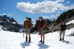 A short walk up the ridge brought us to the top of the La Bohn Gap; we could see over the Chain Lakes and down into Necklace Valley. Mt Hinman raised above us, more a large massive ridge and pile of rocks than a rocky prominent peak. Our goal was to ascend the western slope from the southern side of Hinman and circumnavigate from the south around to the the north slopes across from Mt. Daniel. From the south Hinman has two visible ridges, a large steep cliffy ridge that runs from east to west and a smaller crumbly ridge that runs north and south. Dayhike Mike's description of the rout was : "Looks cliffy, but it goes". Like many things in mountaineering
 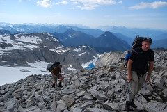 from a distance the route is unclear, but the closer you get a way is found. A large talus ramp starts you up on the ridge and a small trail leads up across the heather and snow ramps finally get you up on top of Hinman's western ridge that runs north and south. This is a very cool walk along the crest of this ridge. The geology of this ridge is very cool, unlike a talus field which is a set of boulder that have carved off a high ridge and reached a settled angle of repose below. This was rocky ridge that had been turned into a big fractured pile of rocks. You could see the way the ice had split the rocks into big slabs, almost like huge dinner plates. Often they were unsettled and would slide one off another. My fingers began getting raw from all the side hilling and grabbing of rocks for balance.
 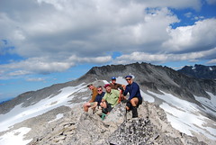 From this western ridge we reached a small saddle where you could look deep down into a cirque above Lake Rowena, still melting out from the winter snow and ice. We carried on up the ridge and a large hump in the middle gave the impression that we were coming to the top of something. We got excited and mistakenly assumed we were almost to the summit of Hinman, we dropped our packs and scrambled to the top. I took my monopod and set up for the summit shot and just after pushing the shutter with the timer Brian said : "What's that big ridge behind us? Isn't that the summit of Hinman?" Oh well, we were on top of something, I named it mid-Hinman summit and we carried on. The day was
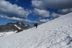 getting late, off trail travel is much much slower than the nice wide graded trails and it was around 4:30. We still weren't close to our planned destination and were worried about running out of day so we opted to not climb Himan's main ridge that runs east and west and has the rocky spirey summit. Instead we stayed at 7100 feet and as we gained the Foss Glacier we traversed around the main west ridge and turned east and continued on the same counter to the eastern edge of the north slope of Hinman. Near the end of the summit ridge the terrain steepens and swiftly descends from 7100 down to 6200 where another rocky shelf interrupts the descent. We were able to get nice long glissades down the steep snow fields, though in shorts one but got a bit cold.
 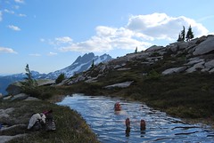 Our original goal for the day was the saddle above Venus on Mt. Daniel's southern spur. However the day had already been a long hard trek and we were ready for camp. So we began looking for a camp on the lower slopes of Hinman. At 6200 feet a shelf begins where the slope levels out and gentle rock appears and is covered with heather and melting water everywhere as we gradually descended. We made our way in a south westerly direction towards the small creek that runs between Mt. Hinman and Mt. Daniel. As we approached the edge of cliffs that sat on the Hinman side above the draw between Daniel and Hinman the slope became more level and there were several perfectly flat shelfs of heather hanging over small rock walk ways amid a couple of beautiful tarns. We settled in for camp, hanging laundry among the trees and exploding packs to find camp shoes and take off our wet boots.
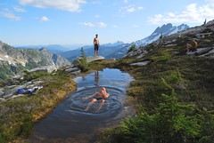 I have never been in a more beautiful campsite, it was almost like a manicured garden with the green heather and the granite rockways. The water flowing everywhere from the melting snow and two perfect tarns that reflected the peaks of Daniels and Bears Breast. One of the tarns was fed by the tiniest trickle of snow melt, and thus the water was around 20 degrees warmer than the pools that had direct runoff from the snow. One by one we all stripped down and dunked our self in the pool. It felt so good to wash off the sweat and grime of the day. Afterwards we boiled water for meals and I cooked one of my favorite backpacking meals : Trader Joe's au gratin potatoes with slices of summer beef stick. Takes a little while to cook, but so so yummy!
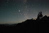
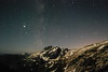
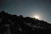
 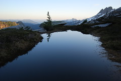 After setting up our tents and bivvy for the night, we all went and sat on one of the rock outcroppings that overlooked Bears Breast and watched the sun set and the last pink clouds fade into dusk. I climbed in my biivy with my mosquito net on but slept without zipping up and quickly fell asleep. I woke up again in the middle of the night when Scott got up to go to the bathroom. The time was around 1:30 am. It was sooo warm that I got out of my bag and didn't even put on a coat. I was immediately struck by the big dipper sitting right above the horizon of Hinman. I grabbed my camera and went and sat on the rock taking pictures for 15 minutes until the moon crested over the ridge of Daniel and I saw my moon shadow. I then trundled off to bed again, knowing that tomorrow would be a tough day heading up Daniel.
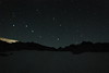
Day Two Stats
6.13 Miles
2884 ascend vertical feet
1730 descend vertical feet
Time on the trail : 9 hours 12 minutes
Photos
| Set on www.flickr.com |
posted by Mark at
11:32 PM
![]()
![]()


1 Comments:
Another good blog about an amazing trip.... still no feeling in my finger tips :)
Post a Comment
<< Home